
SACRAMENTO, Calif —
A wet week is ahead for the entire state of California as a pair of atmospheric river events take aim at the state.
While these storms will bring widespread effects due to periods of moderate to heavy rain, heavy snowfall rates, and gusty winds, misinformation on social media has created worry about widespread flooding which will not be the case.
Instead, these storms will largely be beneficial as the state continues to run a deficit in both snowpack and rain totals due to the lack of atmospheric river events like this upcoming one.
The first storm, expected to arrive on Wednesday afternoon, will follow right on the heels of a period of record warm temperatures for Northern California. Sacramento, San Francisco, Stockton, and many other cities broke their daily record high temperatures on Sunday and Monday as highs rose into the 70s.
Another warm day is expected on Tuesday with highs in the upper 60s in the valley and 50s in the Sierra before a major pattern flip occurs on Wednesday.
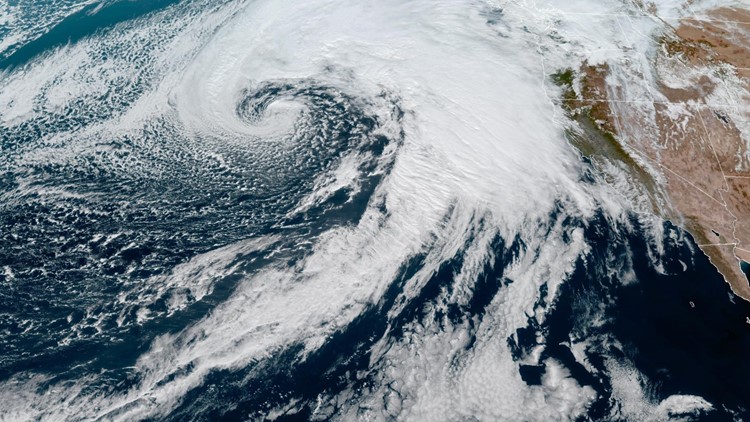
Satellite imagery shows the robust system of low pressure and its associated cold front tapping into subtropical moisture as it nears the West Coast.


There are a few watches and warnings out for Northern California ahead of the first storm, including a Flood Watch, Winter Storm Warning, and a Wind Advisory.
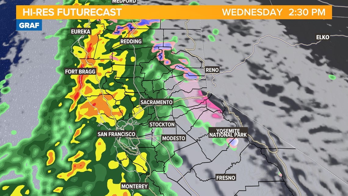
The counterclockwise rotation of the low-pressure system will drag the cold front across the state by around noon on Wednesday.
The futurecast shows rain spreading into interior Northern California after lunchtime. The heaviest rain will occur around midnight in the valley and by Thursday afternoon showers will be scattered along with increased chances of thunderstorms.

Rain totals through Friday will be on the order of 1-3" in the valley and 1.5-3.5" in the foothills with the heaviest totals north of Interstate 80.

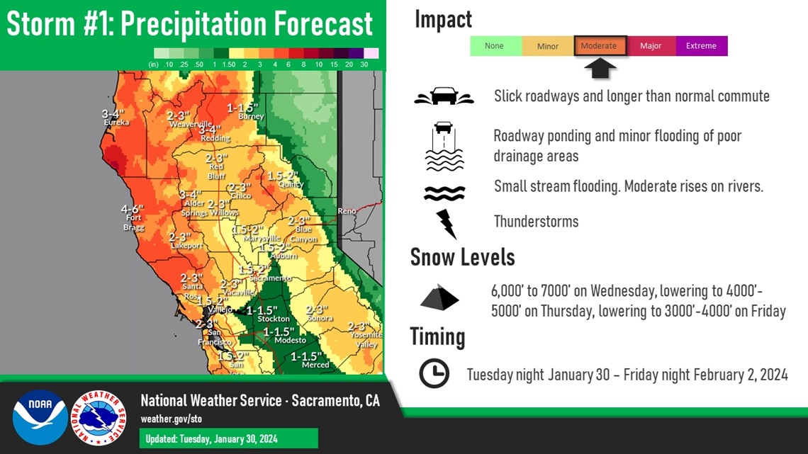
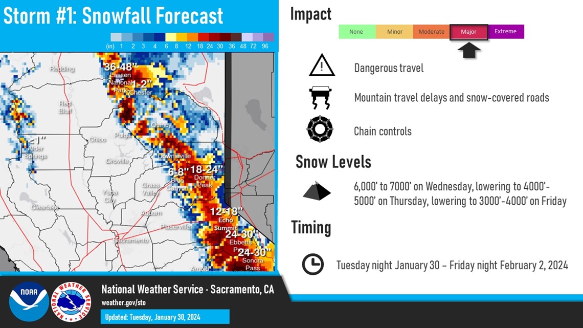
Snow levels will begin fairly high at around 6,000-7,000 feet on Wednesday, dropping to the 4,000-5,000 foot range on Thursday, and ending up as low as 3,000 feet by Friday behind the cold front.
1-2 feet of snow is expected through Friday night with 3 feet possible at mountain peaks. Travel will be difficult, if not impossible, across the Sierra beginning Wednesday afternoon.

The rain and snow will be accompanied by very gusty winds on Wednesday night and into Thursday morning. Gusts of 35-40 mph are expected in the Sacramento area but could be as high as 55 mph in the northern Sacramento Valley. Gusts nearing 65 mph are expected in the Sierra, contributing to the dangerous travel conditions.
High temperatures will also return to below average levels through the week and beyond. By Thursday, daytime temperatures will be back in the 50s and will continue to drop into the weekend.
By Friday, the heavy rain and snow will be out of the area but scattered rain and snow showers are expected. Saturday will be a break before the second, colder storm arrives Sunday.
WATCH ALSO: