

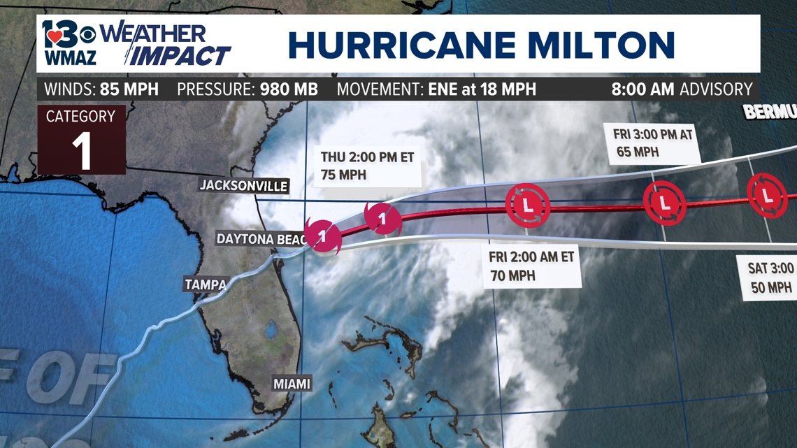
MACON, Georgia — Hurricane Milton is now down to Category 1 strength. Earlier Tuesday, it started an eyewall replacement cycle, and this process dropped it down to a Category 4 storm from Category 5 status after it rapidly intensified on Monday. Milton briefly regained Category 5 status on Tuesday, and made landfall near the Siesta Key area as a Category 3 hurricane with winds sustained of 120 miles per hour. Milton has weakened now to a Category 1 storm as it tracks off the eastern coast of Florida out into the Atlantic Ocean.
Back at home here in central Georgia, breezy conditions will continue throughout this afternoon with gusts up to 30 miles per hour. Cloud cover has exited now as Milton move offshore of Florida.

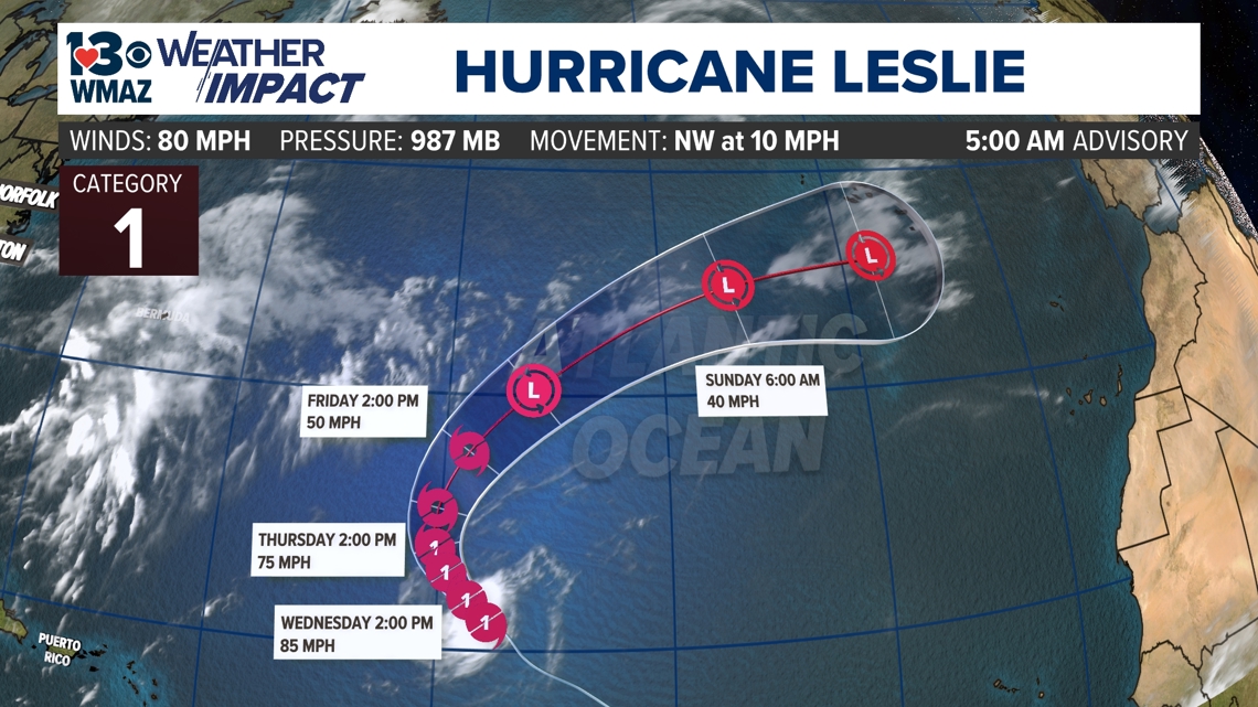
Hurricane Leslie
In the middle of the Atlantic Ocean, Hurricane Leslie formed into our 12th named storm of the hurricane season. Leslie sat at Category 1 hurricane status, weakened back into a tropical storm, and regained Category 1 strength last evening. Leslie will continue to dissipate in the middle of the Atlantic into the weekend. Leslie has not impacted any land masses throughout its lifespan.

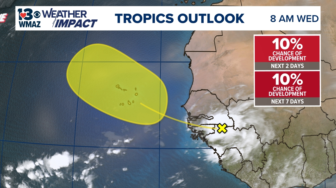
Area of interest in West Africa
The NHC has picked up on another area of potential development on the west coast of Africa. There is a tropical wave in this region that is expected to move westward into the Atlantic and could cause this to develop into a tropical system.
Chances of development at the moment are extremely low, with a 10% chance of development over the next 48 hours and a 10% chance of development in the next 7 days.

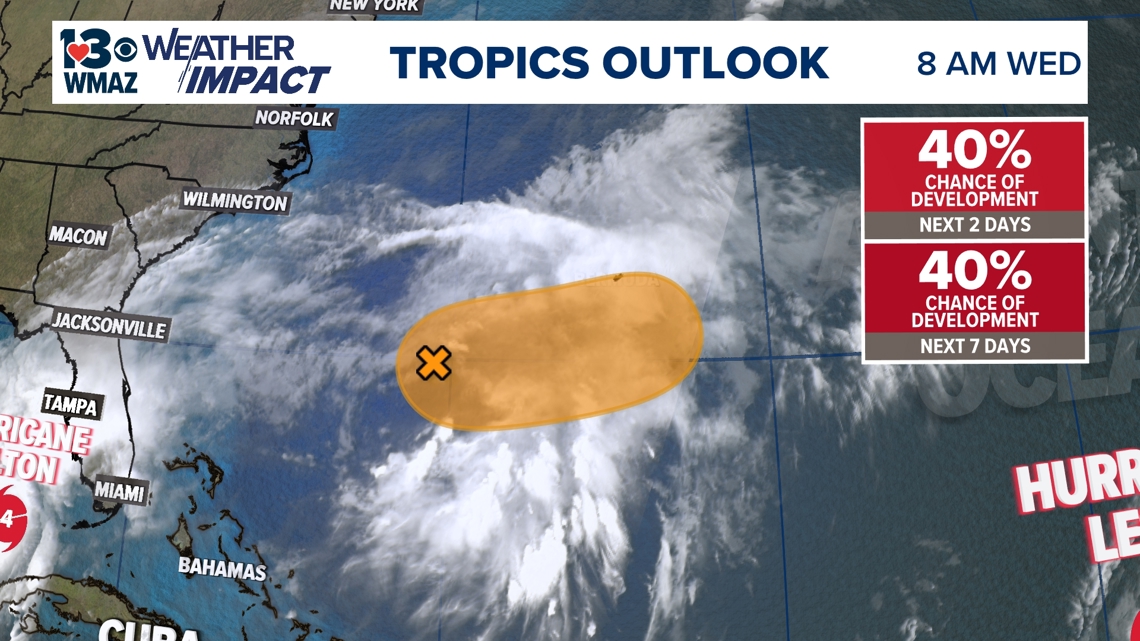
Area of interest in the Western Atlantic
The National Hurricane Center has recently identified an area of showers and storms and tagged it for possible development as it moves east. This area was located in the northern Bahamas yesterday, and chances of developing look better as of this morning as it moves east out into the Atlantic. Chance of development in both the next 48 hours and the next 7 days are 40%.

As we kick off the beginning of October, it's important to remember that the tropics are still very active. We may be past the peak in hurricane season, but strong storms forming in the month of October are not abnormal. Hurricane Michael formed in early October six years ago, and we need no reminder here in central Georgia of the beast that storm was.
However, as of Monday, this was the first time on record that there are 3 named hurricanes in the Atlantic in the month of October or later, before Kirk dissipated in the north Atlantic. Also, Hurricane Milton underwent a rapid intensification that rivaled some of the strongest hurricanes on record in the Atlantic basin, and was only 10 miles per hour and 15 millibars shy of the strongest ever in terms of sustained wind speeds and low-pressure at its strongest late last night.
Two more storms formed while we were focused on covering Helene a little over a week ago, which were Isaac and Joyce. They have since dissipated after claiming the next two names on the list. Now, Kirk has followed suit by disorganizing, and Leslie continues to weaken in the Atlantic as well. With the recent formation of Milton, the 13th name on the list has been claimed. Our next name would be Nadine.


We will continue to monitor the development of this disturbance over the next few days and provide updates as we receive them.