
MACON, Georgia — It has been a couple of days since the arrival of Helene and the tropics continue to stay active. There is one named storm and two areas of interest outlined by the National Hurricane Center that we'll break down.
One area of interest in the Caribbean Sea has prompted some whiplash, considering it is right where Helene had formed last week. But right now, it is too early to tell whether it will form into a hurricane and, if it does, what path it could take.
Here's what you need to know about the tropical developments we are keeping an eye on right now:
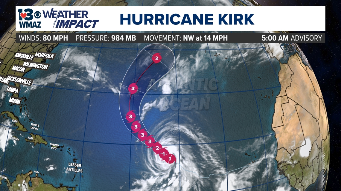
Hurricane Kirk
Hurricane Kirk became the 11th named storm of the 2024 Atlantic Hurricane Season on Monday afternoon. The National Hurricane Center expects the system to be our next major hurricane over the coming days, however, it is still extremely far from North America and the new forecast track from the NHC hints at a northward shift into the middle of the Atlantic Ocean. We will keep an eye on the storm, but as of now Kirk looks to be a "fish storm" and not affect any land masses.

Area of interest near Africa
Right behind Tropical Storm Kirk, another area of interest has emerged off the coast of Africa. This tropical wave is looking promising for development, with a 80% chance of developing over the next 2 days, and a 90% chance of organizing over the next week. Just like Kirk, we'll continue to keep our eye on it as it tracks across the Atlantic. With such strong chances of development, this area looks to eventually organize into our 12th named storm of the Atlantic Hurricane Season, which would be Leslie.


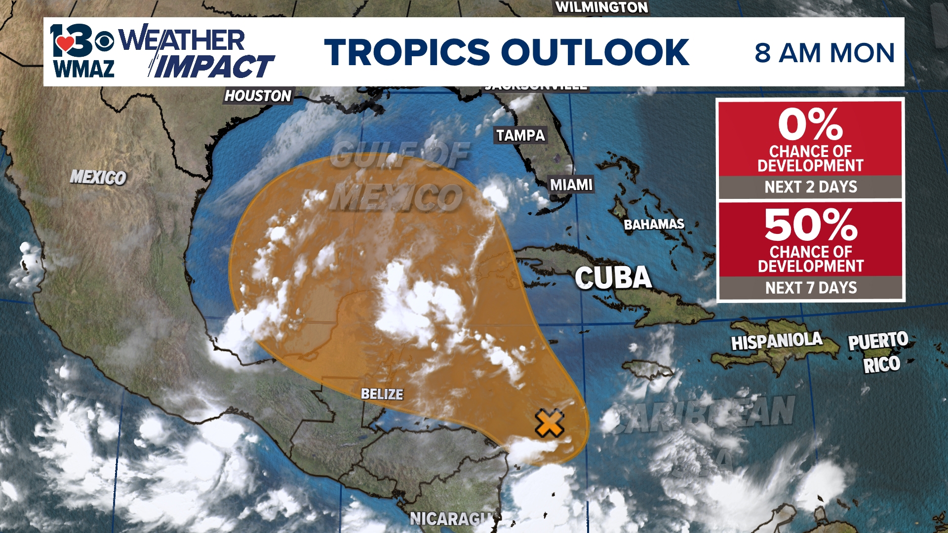
Area of interest in the Caribbean Sea
The area of most relevance and closer to home is exactly where Helene formed in the Caribbean Sea and southern Gulf of Mexico around the Yucatan Peninsula.
Originally this area had a 50% chance of formation with this area over the next week, but the National Hurricane Center has since dropped the chance down to 40%. It had a 10% chance of development over the next 48 hours as of yesterday, but that has since dropped back down to zero.
More details are needed to determine the path it will take.
Some longer-range models are hinting at another track into the southeast at the end of this weekend into next week, but if this system is to get its act together and organize, it does not look near as strong as Helene did.
The other bit of good news with long-range models trends, is that the southeast will see a couple of fronts push down from the north over the course of this weekend and the beginning of next week. Right now this looks to push the tropical moisture farther down south and continues to keep any impacts from this possible tropical system out of central Georgia.
Again, the track of this potential system is anything but certain right now, but with the sensitivity of Helene lingering, it will be something the 13WMAZ Weather Team will continue to update you on as we get a better idea over the next couple of days just like Helene.


As we kick off the beginning of October, it's important to remember that the tropics are still very active. We may be past the peak in hurricane season, but strong storms forming in the month of October are not abnormal. Hurricane Michael formed in early October six years ago, and we need no reminder here in central Georgia of the beast that storm was.
Two more storms formed while we were focused on covering Helene late last week, which were Isaac and Joyce. They have since dissipated after claiming the next two names on the list. Now, Kirk has claimed the next name and we very well could see Leslie form over the next couple of days. So, if this area of interest in the Caribbean does get its act together and organize, the next name after Leslie would be Milton.


We will continue to monitor the development of this disturbance over the next few days and provide updates as we receive them.