Winter seemingly took forever to take hold across a large chunk of the United States this season due to true Arctic air holding back until the middle and latter part of January. However, once it arrived, it did so in a dramatic fashion, helping to set off blockbuster snowstorms across the Midwest and the Northeast as a train of storms slammed into California unleashing heavy rain and yards of mountain snow.
Despite Old Man Winter's fashionably late arrival, he made a no-holds-barred entrance. And AccuWeather forecasters are warning in the company's annual spring forecast, released this week, that the winter hits may keep on coming even well into spring for some regions.
It could be a long ride of wintry weather as the official start of spring is still about six weeks away. Astronomical spring officially begins at the equinox, which will occur at 5:37 a.m. EST on March 20, 2021, and nearly three weeks after the start of meteorological spring, which, year in and year out, starts on the first day of March.
Similar to the winter months, the overall weather pattern across North America will be influenced by a phenomenon known as La Niña. This is a phase during which the water near the equator of the Pacific Ocean is cooler than normal, which, in turn, affects the atmosphere.
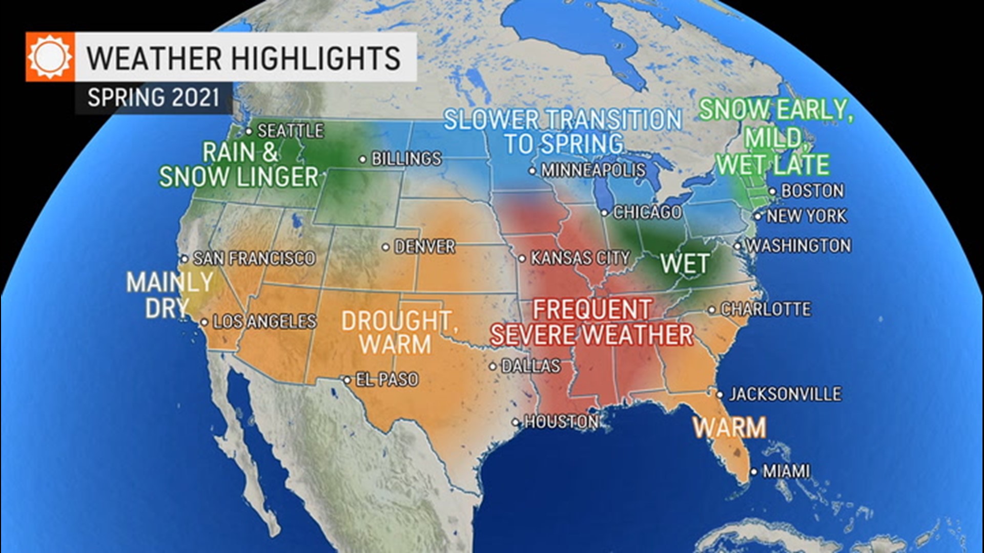
La Niña is projected to continue throughout the spring before weakening heading into early summer, according to AccuWeather Lead Long-Range Meteorologist Paul Pastelok. The effects in the U.S. from La Niña "could create a volatile situation" with an active severe weather season anticipated and more snow chances predicted across the northern tier.
As snow shovels and winter coats get a workout from Maine to Montana and the nation as a whole enters its second year of dealing with the coronavirus pandemic, one region is going to jump straight to spring out of the gate and even get a taste of summer a bit earlier than normal.
Take a look at the complete region-by-region breakdown below.
Northeast
There may be more than just a few April showers across the Northeast this year as a stormy pattern that is expected to take shape at the end of winter will carry over into the new season.
Residents across the Northeast and Midwest can expect "more or less a continuation of winter through the month of March," AccuWeather Senior Meteorologist Dave Samuhel said.
For some big East Coast cities such as Philadelphia, New York City and Boston, the transition into the new season could feature a few big winter storms, which could threaten further disruptions to ongoing coronavirus vaccination efforts.
There will still be the potential for big wintry storms to impact the Northeast well into March, Pastelok said, adding that the active pattern will carry over into April when winter's last gasps will bring about the final chances of snow.
Last year, a major snowstorm blanketed the northern tier of the U.S. on Easter Sunday, leading many to declare "Merry Easter" on social media due to the spring holiday weather's resemblance to weather people normally associate with Christmas.
With Easter arriving on April 4 this year, about a week earlier than last year, a snowy Easter Sunday may not be out of the question for some places, but Pastelok cautioned that the chances of snow happening on Easter Sunday two years in a row are statistically low.
The prospects for snowy weather during the first half of spring will benefit the ski resorts across the Northeast that faced an abridged ski season in the winter of 2019-20 due to the coronavirus pandemic.
"I think they'll be able to stay open later in the Northeast," Pastelok said, noting that the active pattern will lead to opportunities for snow in the higher elevations well into April.
On the flip side of the coin, businesses relying on outdoor areas to operate at a higher capacity amid the pandemic may not like Old Man Winter's extended stay.
In November, AccuWeather conducted a poll asking people "What is the lowest temperature that you would consider dining outdoors?" and nearly half of respondents said that anything below 60 degrees Fahrenheit was too cold.
Businesses such as drive-in movie theaters that have seen a spike in popularity during the pandemic might have to wait until later in April or May before milder, more comfortable conditions return with any regularity.
Midwest
It has been far from a frigid winter across the Midwest, and the lack of ice covering the Great Lakes is evidence of that, but spring weather may be slow to arrive due to a few spells of wintry weather still in the pipeline.
Chicago, Indianapolis and Minneapolis have experienced AccuWeather RealFeel® Temperatures in the single digits on occasion, but a long-duration Arctic blast has not materialized this winter. "We just had a lack of Arctic intrusions," Pastelok explained.
However, Pastelok warns that it is not quite time to put away the heavy winter coats just yet. "We do have more cold air coming in February and into early March," he added.
Late-winter and early-spring cold blasts could increase ice development on the Great Lakes, but ice coverage as a whole has been significantly lower than normal.
Typically around the start of February, around half of Lake Erie is covered in ice, but this year, ice coverage was less than half of that. The other lakes are also experiencing below-normal ice coverage compared to what is usually seen at the start of February.
If bitterly cold air does not have a prolonged presence over the Midwest and the ice coverage on the lakes remains below normal into the early part of spring, it could have implications on the region's weather later in the season.
The water in the lakes was cold in early February, but not terribly cold, so at the end of spring, Pastelok explained, the air temperatures across the Midwest could go through a significant rise. He added that spring in the Midwest could play out like a bit of a roller-coaster ride, and conditions can change dramatically from chilly in March and April to unusually warm in May.
As the cold air begins to loosen its grip, the risk of flooding will be on the rise across portions of the Midwest. "We do think it's gonna get pretty wet later in March and April," Pastelok said.

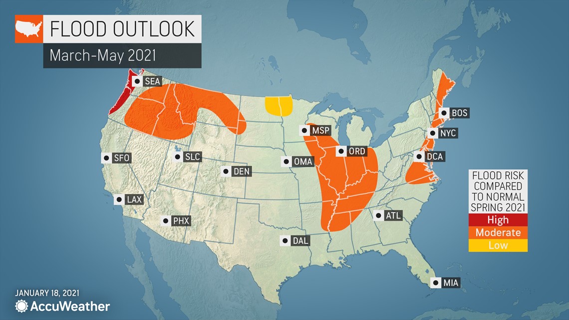
The primary concern is river flooding with some of the region's larger rivers potentially reaching moderate flood stage for a period of time, but it does not look like there will be widespread, record-breaking flooding across the region, Pastelok said.
Southeast
Snowflakes made several appearances across the Deep South this winter, but residents hoping to see some flurries fill the air again shouldn't hold their breath.
"It's been a little chilly across the Gulf Coast," Samuhel said. He then added, "It does look like things will warm up, and we'll have mild weather [lasting] into March."
Pastelok pointed out that there will be opportunities for some chilly days early this spring, especially across the Tennessee Valley and mid-Mississippi Valley, but a deep penetrating cold is likely off the table for Florida and the immediate Gulf Coast.

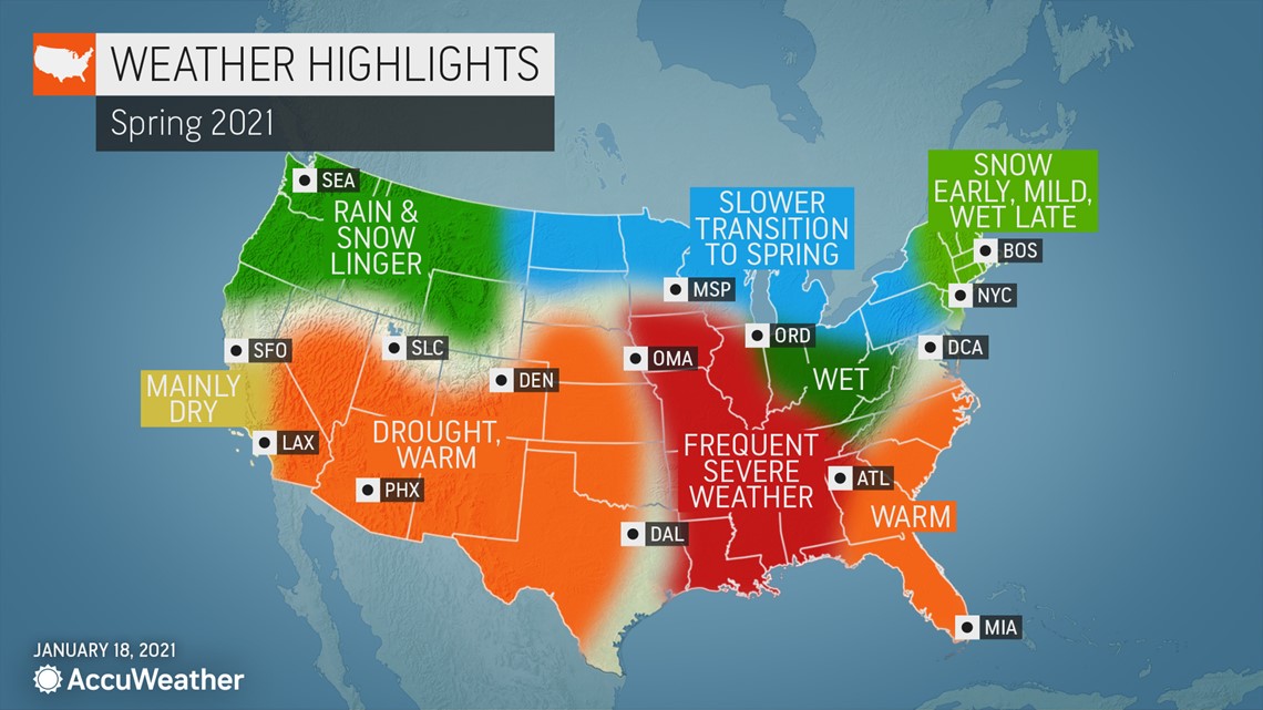
The overall warmer pattern will be a favorable one for farmers from Arkansas to western Georgia, but potential dryness farther east could lead to some pockets of drought from the Carolinas into southeastern Georgia. Not only would this be bad for farmers, but it would raise the risk of brush fires on breezy days.
However, it may not be time to bet the farm on the chances for a drought to develop in the spring, especially if the tail end of winter ends on a wet note.
"We'll see how the rest of winter goes if some moisture can reach down there," Pastelok said. However, even if some late-season rain arrives, the southeastern corner of the country has "been missing out on the big" precipitation events during much of the winter, he said.
Severe weather
Storm chasers may have their hands full during the upcoming severe weather season in the central U.S., but it may take some time for the storms to get going.
Cold air from the north clashing with warm, moisture-rich air from the Gulf of Mexico is the primary driver of severe weather during spring. It could take a while for these ingredients for severe thunderstorms to come together in 2021, limiting the number of severe weather events in March. However, this is expected to change as the calendar flips to April.
"We think that April, for the third year in a row, could be a very active month," Pastelok said.
"I agree with the AccuWeather experts," Extreme Meteorologist Reed Timmer said during an AccuWeather Network special for Groundhog Day. "It's going to be a late start to the severe weather season, but it's going to be incredibly active. I think we're going to be storm chasing a lot in April and May."
However, Timmer may find himself chasing storms farther to the east this severe weather season compared to years past.

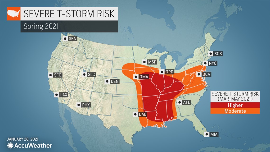
"I think the severe weather season is more shifted toward the central Gulf states and the mid- to- lower-Mississippi Valley," Pastelok said.
St. Louis; Little Rock, Arkansas; Jackson and Tupelo, Mississippi; Nashville and Memphis, Tennessee; Lexington and Paducah, Kentucky; and even Indianapolis are all in the area where AccuWeather is projecting the highest risk of severe thunderstorms from March through May.
The overall weather pattern this spring in the central U.S. has some similarities to that of 2011, which was an extremely active year for severe weather. More than 800 tornadoes were reported in April of 2011, a record for the most tornadoes in a single month. The deadly 2011 Tornado Super Outbreak accounted for more than 40% of these twisters.
The positioning of the jet stream this April is forecast to be very similar to that of April 2011, but Pastelok explained that there are "just a few other factors that I think will hold things back."
One of the factors is the drought over the Four Corners and into part of the High Plains, including eastern Colorado, western Kansas, western Nebraska and part of the Texas Panhandle.
These areas of dryness will inhibit some of the thunderstorm development and are one reason AccuWeather is predicting the focus of tornado activity to occur over an area farther east than the traditional Tornado Alley. Traditionally, Tornado Alley is a tornado-prone swath of the Plains stretching from central Texas to South Dakota.
Western U.S.
California has faced a barrage of storms during the second half of January, including a final powerhouse system that tapped into an atmospheric river of moisture and alleviated drought concerns for most of the state, but a much different story will unfold across the western U.S. as spring arrives.
Exceptional drought conditions were present in Nevada, Utah, Arizona, New Mexico and Colorado, according to the latest U.S. Drought Monitor report on Jan. 28. That's the worst level of drought on the drought intensity scale.

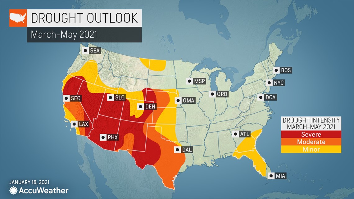
With minimal prospects of significant rain across the interior Southwest and Four Corners, long-term drought conditions will set the stage for early-spring conditions, and it could feel like the season will jump ahead straight into summer for some areas.
"There are a lot of possibilities for early heat waves in the Southwest," Pastelok said.
Death Valley, California, one of the hottest places on Earth, has already hit 90 F this year on Jan. 16, the earliest 90-degree day on record. Similar records could fall elsewhere across the interior Southwest this spring.
Skiers and snowboarders will have to head to California if they want to hit the slopes later in the season as the warm, dry pattern may spell an early end to snow sports at the resorts across Utah, Colorado, New Mexico and Arizona.
As most of the Southwest will bask in abnormal warmth and dry weather this spring, the fire hose of Pacific moisture will keep on targeting the Pacific Northwest into the northern Rockies throughout the duration of the season.
"I think [the storms] come back in, and it keeps going through April at full blast," Pastelok said about the upcoming weather pattern for the Northwest. Even as the calendar flips to May, "I still don't think the unsettled pattern will end. I just think that it will just ease back considerably."
Areas along the Interstate 5 corridor from Medford, Oregon, through Seattle will face a high risk of flooding due to the parade of spring storms, which could end up being a benefit later in 2021. "Remember, these places dried out pretty good [last spring], then we ended up having a really bad fire season in parts of Oregon," Pastelok recalled. "This year is a different setup."
As the spring transpires, residents farther inland, especially those who live at a higher elevation, may begin to wonder if spring will ever arrive, or if 2021 will be the year of a never-ending winter.
"I can still see some snow falling in parts of the northern Rockies and the higher elevations and the interior Northwest all the way into early June," Pastelok said.

