ATLANTA — This summer could once again be another active year in the tropics. Hurricane experts from Colorado State University are predicting an above-average Atlantic season.
The forecast was released by Dr. Philip Klotzbach Thursday during the National Tropical Weather Conference. The initial Colorado State University forecast for the 2022 season includes 19 named storms, nine of which are hurricanes and four major hurricanes.
The average for the Atlantic Basin season is 14.4 named storms, 7.2 hurricanes and 3.2 major hurricanes. This is based on 30 years of data from 1991 to 2020.
If this forecast of an above-average season came to fruition, it would be the seventh above-average season in the Atlantic in a row.
Although they forecast an active season with a greater number of named storms than average, it's much more difficult to predict where any of these will be and how many will make landfall in the United States.


But, the team at Colorado State University has come up with probabilities, with confidence, of a major hurricane making landfall based on the forecast for an active season.
They said there's a 71 percent chance of a major hurricane, which would be a Category 3 storm or stronger, making landfall along the U.S. coastline, which is significantly higher than the average of around 52 percent on any given year. On the flip side, this also means there is a nearly 30 percent chance there won't be a major hurricane making landfall this upcoming season.
On the east coast of the U.S., the team is calling for a 47 percent chance of a major hurricane making landfall, compared to the average of a 3 in 10 chance.
Forecasters also said that there's an 82 percent chance that a named storm, such as a tropical depression, will track within 50 miles of the Georgia coastline. The team added there's a 46 percent chance that a hurricane could track within 50 miles of Georgia's coast.
Remember, it only takes one storm to bring significant impacts to an area. The last several hurricane seasons have brought highly impactful systems to Georgia. In 2021, six tornadoes were confirmed as the remnants of Tropical Storm Fred moved through the state. And in 2020 Georgia, Tropical Storm Zeta brought strong winds resulting in widespread power outages that lasted for days.
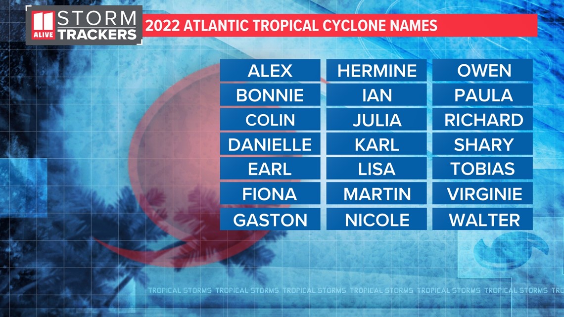
2022 Hurricane Names
The list of tropical cyclone names repeats every 6 years. A name is only removed and replaced when it is retired by the World Meteorological Organization. The group retires names from storms that have caused significant devastation and damage.
Here is this year's list of names. If storms blow this list, meteorologists would then move to a supplemental list of tropical cyclone names. The Greek Alphabet is no longer used.


Climate Patterns Behind The Forecast
The team at Colorado State University used a combination of statistical and climate weather models, as well as analog years (years with similar atmospheric/ocean conditions to compare to) to come up with their forecast.
Klotzbach's discussion of the seasonal tropical outlook focused around a few different forecasting components including the El Niño Southern Oscillation (ENSO), subtropical and tropical Atlantic ocean temperatures, and what may happen to large scale wind patterns to change ocean temperatures.
A primary driver for forecasting an upcoming Atlantic hurricane season is often the presence or lack of an El Niño. For this, scientists look at the ocean surface temperatures over the Eastern Pacific Ocean near the equator. When they are cooler than normal, there is a La Niña. When they are warmer than normal, there is an El Niño. When neither is present, meteorologists call it a neutral phase of ENSO.
Presently, there are cooler than normal temperatures on the sea surface in this region of the globe, meaning we are in a La Niña. ENSO is likely to transition to neutral conditions by the summer or fall, but a significant El Niño is unlikely. When an El Niño is present, more wind shear limits hurricane development.
Another good indicator is early April ocean temperatures in the eastern Atlantic near Portugal. When they are warmer than average, this can correlate to warmer ocean surface temperatures in the tropical and subtropical Atlantic in the more active months in the tropics.
CSU's three-pronged approach to seasonal forecasting with statistical models, climate models, and analog years, helps to create good confidence in their hurricane outlooks.

